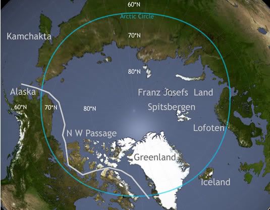
The Northwest Passage is a sea route through the Arctic Ocean along the northern coast of North America via the waterways amidst the Canadian Arctic Archipelago, connecting the Atlantic and Pacific Oceans.[1][2] The various islands of the archipelago are separated from one another and the Canadian mainland by a series of Arctic waterways collectively known as the Northwest Passages or Northwestern Passages.[3]
Sought by explorers for centuries as a possible trade route, it was first navigated by Roald Amundsen in 1903-6. The Arctic pack ice prevents regular marine shipping throughout the year, but climate change, due to global warming in modern times, is reducing the pack ice and may eventually make the waterways more navigable. This and the contested sovereignty claims over the waters may complicate future shipping through the region. The Canadian government considers the Northwestern Passages part of Canadian Internal Waters,[4] but various countries maintain they are an international strait or transit passage, allowing free and unencumbered passage.
http://en.wikipedia.org/wiki/Northwest_Passage
Northwest Passage
http://www.answers.com/topic/northwest-passage?cat=travel
The Northwest Passage is a sea route connecting the Atlantic and Pacific Oceans through the Arctic Archipelago of Canada. The various islands of the archipelago are separated from one another and the Canadian mainland by a series of Arctic waterways collectively known as the Northwest Passages or Northwestern Passages. The Canadian military refers to the sea route exclusively as the Canadian Internal Waters.
Between the end of the 15th century and the 20th century, Europeans attempted to discover a commercial sea route north and west around North America. The English called the hypothetical route the Northwest Passage, while the Spanish called it the Strait of Anián. The desire to establish such a route motivated much of the European exploration of both coasts of North America.
At the same time explorers were attempting to find this westbound passage between the Atlantic and Pacific north of the North American mainland, others were competing to find an eastbound passage north of Russia, i.e. a Northeast passage.
First attempts during the Little Ice Age
- 1539: Hernán Cortés commissioned Francisco de Ulloa to sail along the peninsula of Baja California in search of the Strait of Anián.
- 1576 - 1578: Martin Frobisher took three trips to what is now the Canadian Arctic in order to find the passage. Frobisher Bay, which he discovered, is named after him.
- July 1583: Sir Humphrey Gilbert, who had written a treatise on the discovery of the passage and was a backer of Frobisher's, claimed the territory of Newfoundland for the English crown.
- 8 August 1585: The English explorer John Davis entered Cumberland Sound, Baffin Island.
- 1609: Henry Hudson sailed up the river that now bears his name in search of the passage; he later explored the Arctic and Hudson Bay.
- 1619: Norwegian Jens Munk sought the passage.
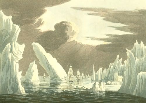
- 1762: The English trading ship Octavius supposedly hazarded the passage, but became trapped in sea ice.
- 1775: The whaler Herald found the Octavius drifting near Greenland with the bodies of her crew frozen below decks. Thus the Octavius may have earned the distinction of being the first Western sailing ship to make the passage, although the fact that it took 13 years and occurred after the crew was dead somewhat tarnishes this achievement. (The veracity of the Octavius story is questionable.)
- 1791-1795: The Vancouver Expedition surveys in detail all passages from the Northwest Coast, confirming that there is no such passage south of the Bering Strait.[1]
In the first half of the 19th century, some parts of the Northwest Passage were explored separately by a number of expeditions, including those by John Ross, William Edward Parry, James Clark Ross; and overland expeditions led by John Franklin, George Back, Peter Warren Dease, Thomas Simpson, and John Rae. Sir Robert McClure was credited with the discovery of the Northwest Passage in 1851 when he looked across McClure Strait from Banks Island and viewed Melville Island. However, this strait was not navigable to ships at that time, and the only usable route, linking the entrances of Lancaster Strait and Dolphin and Union Strait was discovered by John Rae in 1854.
Although most Northwest Passage expeditions originated in Europe or on the east coast of North America and sought to traverse the Passage in the westbound direction, some progress was made in exploration of its western end as well. Semyon Dezhnev was the first European to reach Alaska and discover the Bering Strait in 1648.
- In 1728, Vitus Bering sailed to Bering Strait from the Pacific.
- In 1776, James Cook set sail from England in search of the Northwest Passage from the Pacific.
- In 1825, Frederick William Beechey explored the North coast of Alaska, discovering Point Barrow.
Sir John Franklin expedition
In 1845, a well-equipped two-ship expedition led by Sir John Franklin sailed to the Canadian Arctic to chart the final unknown parts of the Northwest Passage. Confidence was high, as there was less than 500 km of unexplored Arctic mainland coast left. When it failed to return, a number of relief expeditions and search parties explored the Canadian Arctic, resulting in final charting of a possible passage. Traces of the expedition have been found, including records that indicate that the ships became ice-locked in 1846 near King William Island, about half way through the passage, and were unable to extricate themselves. Franklin himself died in 1847 and the last of the party in 1848, after abandoning the ships and attempting to escape overland by sledge. While starvation and scurvy contributed to the deaths of the crew, another factor was significant. The expedition took 8000 tins of food which were soldered with lead. The lead contaminated the food, poisoning the crew. They would have become weak and disoriented—later stages of lead poisoning include insanity and death. In 1981, Dr. Owen Beattie, an anthropologist from the University of Alberta examined remains from sites associated with the expedition. This led to further investigations, and the examination of tissue and bone from the mummified bodies of three seamen, exhumed from the permafrost of Beechey Island. Laboratory tests revealed high concentrations of lead in all three. New evidence shows that cannibalism was also a factor which may have contributed to the deaths of the crew.
McClure expeditionDuring the search for Franklin, Commander Robert McClure and his crew in HMS Investigator traversed the Northwest Passage from west to east in the years 1850 to 1854, partly by ship and partly by sledge. McClure started out from England in December of 1849, sailed the Atlantic Ocean south to Cape Horn and entered the Pacific Ocean. He sailed the Pacific north with a stop at Hawaii and then finally passing through the Bering Strait turning east at that point and reaching Banks Island. McClure's ship was trapped in the ice for three winters near Banks Island, at the western end of Viscount Melville Sound. Finally McClure and his crew – who were by that time dying of starvation — were found by searchers travelling by sledge over the ice from one of the ships of Sir Edward Belcher's expedition, and returned with them to Belcher's ships, which had entered the sound from the east. On one of Belcher's ships, McClure and his crew returned to England arriving in 1854 becoming the first people to circumnavigate the Americas, discover and transit the North West Passage in their journey, albeit by ship and by sledge over the ice. This was an astonishing feat for that day and age and McClure was knighted and promoted to Captain and both he and his crew shared £10,000 awarded them by the British Parliament.
Explorations by John Rae
The expeditions by Franklin and McClure were in the then-current tradition of British exploration: Well-funded ship-borne expeditions using modern technology, and usually including British Naval personnel. By contrast, John Rae was an employee of the Hudson's Bay Company. The Hudson's Bay Company was the major driving force behind the exploration of the Canadian North. They adopted a pragmatic approach and tended to be land-based. While Franklin and McClure attempted to explore the passage by sea, Rae explored by land, using dog sleds and employing techniques he learned from the native Inuit. The Franklin and McClure expeditions each employed hundreds of personnel and multiple ships, and ended in failure. John Rae's expeditions included less than ten people and succeeded. Rae was also the only exploreer to traverse these lands without ever losing a man. In 1854 [2], Rae returned with information about the fate of the ill-fated Franklin expedition.
Amundsen expedition
The Northwest Passage was not conquered by sea until 1906, when the Norwegian explorer Roald Amundsen, who had sailed just in time to escape creditors seeking to stop the expedition, completed a three-year voyage in the converted 47-ton herring boat Gjøa. At the end of this trip, he walked into the city of Eagle, Alaska, and sent a telegram announcing his success. His route was not commercially practical; in addition to the time taken, some of the waterways were extremely shallow.
Later expeditions
The first single-season passage was not accomplished until 1944, when the Canadian ship St. Roch, a Royal Canadian Mounted Police schooner commanded by the Canadian RCMP officer Henry Larsen, made it through to reinforce Canadian sovereignty of the Northwest Passage.
Only one person had ever sailed a ship through the famed Northwest Passage, Norwegian Roald Amundsen in 1903-06, from east to west by way of Rae Strait. In the spring of 1854, John Rae had observed that this strait contained young ice and, as such, was navigable. In 1940, Larsen was the first to sail it from west to east, from
The first traversal of the Northwest Passage via dog sled[3] was accomplished by Greenlander Knud Rasmussen while on the Fifth Thule Expedition (1921-1924). Rasmussen, and two Greenland Inuit, traveled from the Atlantic to the Pacific over the course of 16 months via dog sled.
On July 1, 1957, the U.S. Coast Guard cutter Storis departed in company with U.S. Coast Guard cutters Bramble (WLB-392) and SPAR (WLB-403) to search for a deep draft channel through the Arctic Ocean and to collect hydrographic information. This historic transit ended a 450-year search for the Northwest Passage – a route for large ships across the top of North America. Upon her return to Greenland waters, the Storis became the first U.S. registered vessel to circumnavigate the North American continent. Shortly after her return in late 1957, she was reassigned to her new home port of Kodiak, Alaska.
In 1969, the SS Manhattan made the passage, accompanied by the Canadian icebreaker John A. Macdonald. The Manhattan was a specially reinforced supertanker sent to test the viability of the passage for the transport of oil. While the Manhattan succeeded, the route was deemed not cost effective and the Alaska Pipeline was built instead.
In June 1977, Dutch sailor Willy de Roos left Belgium to attempt crossing the Northwest Passsage in his 45-foot steel yacht Williwaw. He reached the Bering Strait in September and after a stopover in Victoria, British Columbia went on to round Cape Horn and sail back to Belgium, thus being the first sailor to circumnavigate the Americas entirely by ship.
In October, 2005, a 47-foot aluminum sailboat, Northabout, built and captained by Jarlath Cunnane, a retired construction manager, completed the first east-to-west circumnavigation of the pole by a single sailboat using the increasingly open Northwest Passage to get from Ireland to the Bering Strait in 2001. The voyage from the Atlantic to the Pacific was completed in a very fast time of 24 days — from sailing into Lancaster Sound off Baffin Bay on August 7 to reaching the Bering Strait, Alaska on September 1. The Northabout then cruised in Canada for two years. The return Northeast Passage along the coast of Russia was slower, starting in 2004, with an ice stop/winter over in Khatanga, Siberia — hence the return to Ireland via the Norwegian coast in October 2005. On January 18, 2006, The Cruising Club of America awarded Jarlath Cunnane their Blue Water Medal, an award for "meritorious seamanship and adventure upon the sea displayed by amateur sailors of all nationalities."
International waters dispute
The Canadian government claims that the waters of the Northwest Passage are internal to Canada.
In 1985, the U.S. icebreaker Polar Sea passed through, and the U.S. Government made a point of not asking permission from the Canadians. They claimed that this was simply a cost-effective way to get the ship from Greenland to Alaska and that there was no need to ask permission to travel through international waters. The Canadian government issued a declaration in 1986 reaffirming Canadian rights to the waters. However, the United States refused to recognize the Canadian claim.
In late 2005, it was alleged that U.S. nuclear submarines had traveled unannounced through Canadian Arctic waters, sparking outrage in Canada. In his first news conference after the federal election, then-Prime Minister-designate Stephen Harper contested an earlier statement made by the American ambassador that Arctic waters were international, stating the Canadian government's intention to enforce its sovereignty there.
The allegations arose after the U.S. Navy released photographs of the USS Charlotte surfaced at the North Pole. A submarine traveling between oceans by way of the Pole would have to travel over a thousand kilometers out of its way to use the Northwest Passage (as opposed to simply heading directly to either ocean). Furthermore, shallow waters and underwater navigational uncertainties would force it to move very slowly and carefully within the Northwest Passage to avoid running aground; by contrast, it could travel at full speed in the deep, open waters under the Pole.
On April 9, 2006, Canada's Joint Task Force North declared that the Canadian military will no longer refer to the region as the Northwest Passage, but as the Canadian Internal Waters.[4] The declaration came after the successful completion of Operation Nunalivut (Inuit for "the land is ours"), which was an expedition into the region by five military patrols. [5]
Effects of global warming
Around the time of the Viking Sagas and for at least two more centuries (a conservative interval from 1000–1200 AD that also happens to include the dates allotted to some of the larger Norse ships), prior to the Little Ice Age the climate was not only warmer, but the sea-level in the Arctic was also quite different from that of the present day.[6] Between the glacial rebound and global cooling, land levels of the land masses about the Northwest Passage have risen upwards to the order of 20m in the centuries after the Viking times.
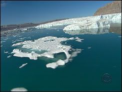
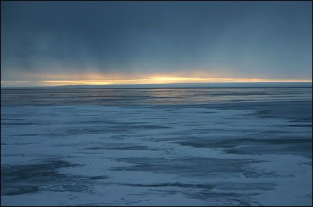
In the summer of 2000, several ships took advantage of thinning summer ice cover on the Arctic Ocean to make the crossing. It is thought that global warming is likely to open the passage for increasing periods of time, making it attractive as a major shipping route. Routes from Europe to the Far East save 4000 km through the passage, as compared to the current routes through the Panama Canal.
Trivia
In 1981, Canadian folk singer Stan Rogers recorded the song "Northwest Passage", based on the history of attempts to establish the route. It appeared on his album of the same title.
In 2007 author Dan Simmons published The Terror - a fictionalised account of the Franklin expedition that, while based on a supernatural premise, draws heavily from the historical records.
North-West PassageMaps of the Northwest Passage
http://www.athropolis.com/map9.htm
Northwest Passage
http://www.athropolis.com/links/nwpass.htm
XMany ships and explorers had passed through these dangerous waters before - following the North Star in search of the Northwest Passage.
Northwest Passage History
http://www.norwegianblue.co.uk/history.htm
The National :Northwest Passage
Global warming may turn deadly route through ice into plain sailing
The perilous dream of a North-west Passage is likely to become a commercial and problematic reality
http://www.guardian.co.uk/climatechange/story/0,12374,878287,00.html
The North-west Passage, for centuries a forbidding and deadly challenge to explorers and adventurers, is being so transformed by global warming that it may change the face of international transport.
Scientists predict that it may be free of ice within 50 years, opening it to cruise vessels, tankers and warships. It is already being nicknamed "Panama Canal North".
US naval officers have circulated a report arguing the case for a new type of ice-strengthened warship to patrol Arctic waters, according to the Los Angeles Times. This summer the Canadian navy sent ships north of the Arctic Circle for the first time since the cold war ended.
While the global temperature has risen 1F (about 0.6C) in the past century, the Arctic temperature has risen 3-4F (1.7-2.2C). This has already had a dramatic effect on the landscape and if it continues at the current pace it may have even greater consequences.
"The image of the Arctic was always one of an ice-locked, forbidden spot," James Delgado, director of the Vancouver Maritime Museum and the author of Across the Top of the World: The Quest for the Northwest Passage, told the Los Angeles Times.
"If we as a species have wrought this change it's humbling, given its history as such a terror-filled place."
In summer long stretches of the North-west Passage are free of ice, making the voyage relatively simple.
Its attraction is that it would reduce the voyage from Europe to Asia by up to 5,000 miles and provide an inviting new route for "adventure tours."
Tourists have already begun to appear. A sailing boat from New Zealand recently traversed the route successfully.
"It's something no one would have dreamed up for our lifetime," said Lawson Brigham, deputy director of the US Arctic Research Commission and former captain of the US coastguard icebreaker Polar Sea, which made the passage in 1994.
Green lobbyists point to a threat to indigenous peoples. "Climate change upsets the dynamics of marine and coastal ecosystems and native cultures that depend on them," Greenpeace said in a 1998 report, Answers from the Ice Edge.
"The consequences of global warming are affecting the subsistence way of life of Alaska's Native people now... Climate-caused changes in subsistence ways of life may be the greatest threat to the continued existence of indigenous cultures."
Its study of the effect of climate change on life in the Bering and Chukchi Seas found that native peoples had been warning of the changes for years without being taken seriously.
If the North-west Passage is opened commercially it will have a significant effect on these small communities.
The Canadian Inuit territory Nunavut has just over 25,000 people in 1.9m sq km (750,000 sq miles). A transport boom would have an unpredictable effect on them.
"It's not just about transport, it's about the whole development of the Arctic frontier," said Lynn Rosentrater, a climate change officer for the WWF in Norway. "It's going to happen, so we need to plan for it."
Development of the passage would lead to maritime problems between the US and Canadian governments.
Other regions are watching their way of life being changed dramatically by the effects of global warming. Alaska is examining the effect on the people on the edge of the Arctic Circle.
They have seen lakes dry up, the treeline move, and subsequent alterations in the pattern of hunting. Scientists in Fairbanks, Alaska, have seen changes in the forest system and the tundra.
The global warming issue was given new urgency when President Bush said after taking office that he would not accept the Kyoto protocol setting out national targets for reducing the 1990 greenhouse gas emissions globally by 5.2% by 2008-12.
The US environmental protection agency accepts that there will be changes.
"Rising global temperatures are expected to raise sea level, and change precipitation and other local climate conditions," its website says.
"Changing regional climate could alter forests, crop yields, and water supplies. It could also affect human health, animals, and many types of ecosystems.
"Deserts may expand into existing rangelands, and features of some of our national parks may be permanently altered."
Report on the Northwest Passage
Will ice melt open fabled Northwest Passage?
Researchers say Arctic route could thaw in next decade
http://archives.cnn.com/2002/TECH/science/08/29/northwest.passage/
WASHINGTON (CNN) -- Rapid melting of the Arctic ice pack may turn a cherished sailor's myth into reality. The Northwest Passage, the legendary shipping shortcut from the Atlantic to the Pacific, could be ice-free in as few as 10 years, many predict.
A well-documented continuing Arctic thaw is reducing polar ice, a change that is likely to have profound effects on commerce, ecology and native cultures, according to author Richard Kerr, writing in the journal Science.
The fabled route runs below Iceland and Greenland, through the Arctic archipelago in northern Canada, and along the northern coast of Alaska between the Pacific and Atlantic oceans.
An ice-free Northwest Passage would let ships traveling between Europe and Asia shave more than 4,000 miles off the route through the Panama Canal and would allow ships to avoid the occasional delays and the passage fees of the canal.
In addition, many of the largest container and tanker ships cannot fit in the 88-year-old canal, forcing shippers to use smaller vessels or to take the even longer, more treacherous route around South America's Cape Horn.
A threat to environment?
But the potential windfall for shippers could threaten native cultures and Arctic wildlife.
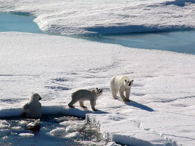
The combination of declining ice and dramatically increased ship traffic could alter the feeding habits of fish, seals and polar bears, further threatening the traditional way of life of the Inuit communities that depend on ice-bound Arctic creatures for their survival.
The specter of an Exxon Valdez-like oil spill also raises concern throughout the region, Kerr wrote.
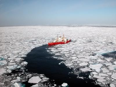
Shipping experts caution the passage probably would be safe for shipping traffic only in the summer, and ships using the Arctic route would need substantial investment in reinforced hulls to survive ice collisions or entrapment.
Kerr cited the work of the U.S. Arctic Research Commission, which predicts that in as little as a decade ships would find ice-free passage in the summer months.
More conservative climate models show the Northwest Passage opening before the year 2080 at the latest.
Kerr's article appeared in the August 30 edition of Science. His work is a news report, not a peer-reviewed study.
Global Warming May Open Northwest Passage
As Arctic Ice Retreats To Record Low, Elusive Shipping Route Could Open Sooner Than Thought
http://www.cbsnews.com/stories/2007/09/15/tech/main3263931.shtml?source=RSSattr=Business_3263931
Arctic ice has shrunk to the lowest level on record, new satellite images show, raising the possibility that the Northwest Passage that eluded famous explorers will become an open shipping lane.
The European Space Agency said nearly 200 satellite photos this month taken together showed an ice-free passage along northern Canada, Alaska and Greenland, and ice retreating to its lowest level since such images were first taken in 1978.
The waters are exposing unexplored resources, and vessels could trim thousands of miles from Europe to Asia by bypassing the Panama Canal. The seasonal ebb and flow of ice levels has already opened up a slim summer window for ships.
Leif Toudal Pedersen, of the Danish National Space Center, said that Arctic ice has shrunk to some 1 million square miles. The previous low was 1.5 million square miles, in 2005.
“The strong reduction in just one year certainly raises flags that the ice (in summer) may disappear much sooner than expected,” Pedersen said in an ESA statement posted on its Web site Friday.
Pedersen said the extreme retreat this year suggested the passage could fully open sooner than expected - but ESA did not say when that might be. Efforts to contact ESA officials in Paris and Noordwik, the Netherlands, were unsuccessful Saturday.
A U.N. panel on climate change has predicted that polar regions could be virtually free of ice by the summer of 2070 because of rising temperatures and sea ice decline, ESA noted.
Russia, Norway, Denmark, Canada and the United States are among countries in a race to secure rights to the Arctic that heated up last month when Russia sent two small submarines to plant its national flag under the North Pole. A U.S. study has suggested as much as 25 percent of the world's undiscovered oil and gas could be hidden in the area.
Environmentalists fear increased maritime traffic and efforts to tap natural resources in the area could one day lead to oil spills and harm regional wildlife.
Until now, the passage has been expected to remain closed even during reduced ice cover by multiyear ice pack - sea ice that remains through one or more summers, ESA said.
Researcher Claes Ragner of Norway's Fridtjof Nansen Institute, which works on Arctic environmental and political issues, said for now, the new opening has only symbolic meaning for the future of sea transport.
“Routes between Scandinavia and Japan could be almost halved, and a stable and reliable route would mean a lot to certain regions,” he said by phone. But even if the passage is opening up and polar ice continues to melt, it will take years for such routes to be regular, he said.
“It won't be ice-free all year around and it won't be a stable route all year,” Ragner said. “The greatest wish for sea transportation is streamlined and stable routes.”
“Shorter transport routes means less pollution if you can ship products from A to B on the shortest route,” he said, “but the fact that the polar ice is melting away is not good for the world in that we're losing the Arctic and the animal life there.”
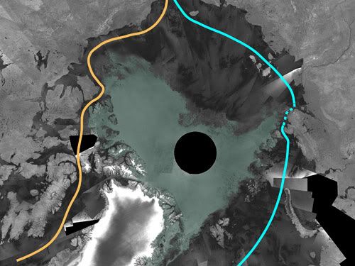
The opening observed this week was not the most direct waterway, ESA said. That would be through northern Canada along the coast of Siberia, which remains partially blocked.
Arctic Melt Opens Northwest Passage
http://dsc.discovery.com/news/2007/09/17/arcticmelt_pla.html?category=earth&guid=20070917103030&dcitc=w19-502-ak-0000
Arctic ice has shrunk to the lowest level on record, new satellite images show, raising the possibility that the Northwest Passage that eluded famous explorers will become an open shipping lane.
The European Space Agency said nearly 200 satellite photos this month taken together showed an ice-free passage along northern Canada, Alaska and Greenland, and ice retreating to its lowest level since such images were first taken in 1978.
The waters are exposing unexplored resources, and vessels could trim thousands of miles from Europe to Asia by bypassing the Panama Canal. The seasonal ebb and flow of ice levels has already opened up a slim summer window for ships.
Leif Toudal Pedersen, of the Danish National Space Center, said that Arctic ice has shrunk to some 1 million square miles. The previous low was 1.5 million square miles, in 2005.
"The strong reduction in just one year certainly raises flags that the ice (in summer) may disappear much sooner than expected," Pedersen said in an ESA statement posted on its Web site Friday.
Pedersen said the extreme retreat this year suggested the passage could fully open sooner than expected — but ESA did not say when that might be. Efforts to contact ESA officials in Paris and Noordwik, the Netherlands, were unsuccessful Saturday.
A U.N. panel on climate change has predicted that polar regions could be virtually free of ice by the summer of 2070 because of rising temperatures and sea ice decline, ESA noted.
Russia, Norway, Denmark, Canada and the United States are among countries in a race to secure rights to the Arctic that heated up last month when Russia sent two small submarines to plant its national flag under the North Pole. A U.S. study has suggested as much as 25 percent of the world's undiscovered oil and gas could be hidden in the area.
Environmentalists fear increased maritime traffic and efforts to tap natural resources in the area could one day lead to oil spills and harm regional wildlife.
Until now, the passage has been expected to remain closed even during reduced ice cover by multi-year ice pack — sea ice that remains through one or more summers, ESA said.
Researcher Claes Ragner of Norway's Fridtjof Nansen Institute, which works on Arctic environmental and political issues, said for now, the new opening has only symbolic meaning for the future of sea transport.
"Routes between Scandinavia and Japan could be almost halved, and a stable and reliable route would mean a lot to certain regions," he said by phone. But even if the passage is opening up and polar ice continues to melt, it will take years for such routes to be regular, he said.
"It won't be ice-free all year around and it won't be a stable route all year," Ragner said. "The greatest wish for sea transportation is streamlined and stable routes."
"Shorter transport routes means less pollution if you can ship products from A to B on the shortest route," he said, "but the fact that the polar ice is melting away is not good for the world in that we're losing the Arctic and the animal life there."
The opening observed this week was not the most direct waterway, ESA said. That would be through northern Canada along the coast of Siberia, which remains partially blocked.
Melting ice opens new door
Northwest Passage Opens Up
http://www.livescience.com/imageoftheday/siod_070914.html
Arctic sea ice shrunk this week to its lowest level since satellite measurements began nearly 30 years ago, so much that it has opened up the most direct route of the Northwest Passage--a legendary frozen sea route above North America and Siberia linking the Atlantic and Pacific oceans.
Arctic sea ice normally recedes in the summer, but satellite data collected by the European Space Agency's Envisat probe, has shown that the overall rate of ice loss has sped up drastically in the past 10 years.
"There has been a reduction of the ice cover over the last 10 years of about 100,000 square kilometers [62,137 square miles] per year on average," said Leif Toudal Pedersen of the Danish National Space Centre, "so a drop of 1 million square kilometers [621,371 square miles] in just one year is extreme."
While the Northeast Passage along the Siberian coast remains partially blocked, the Passage's most direct route now is navigable across northern Canada. However, Pedersen says, the complete passage may open sooner than expected.
The fabled Northwest Passage, if fully navigable, could make the trip 4,000 miles shorter for ships traveling between Europe and Asia if they could avoid the Panama Canal route. The passage was first navigated by explorer Roald Amundsen in 1903 to 1906.
Even when the Arctic ice pack dropped to a previous low of 4 million square kilometers in 2005, the passage did not fully open, Pedersen said.
Earth's polar regions are highly vulnerable to rising temperatures spurred by climate change. While the UN’s Intergovernmental Panel on Climate Change predicts an ice-free Arctic summer by 2070, other scientists foresee such a scenario as early as 2040.
Fight for the Top of the World
http://www.time.com/time/world/article/0,8599,1663445,00.html
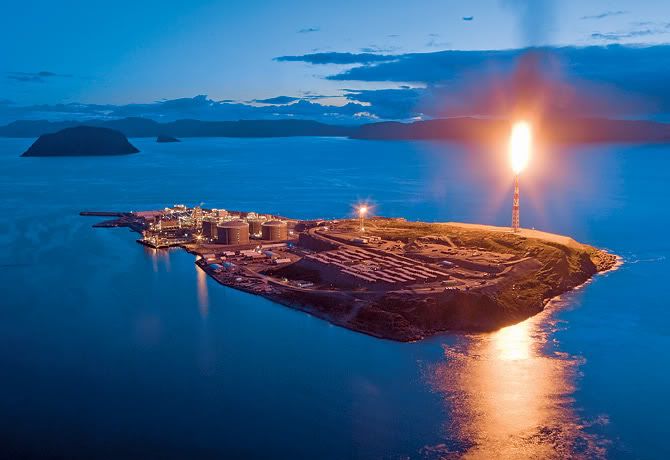
At the end of august, a wisp of flame suddenly appeared in the Arctic twilight over the Barents Sea, bathing the low clouds over the Norwegian port of Hammerfest in a spectral orange glow. With a tremendous roar, the flame bloomed over the windswept ocean and craggy gray rocks, competing for an instant with the Arctic summer's never-setting sun. The first flare-off of natural gas from the Snohvit (Snow White in Norwegian) gas field, some 90 miles (145 km) offshore, was a beacon of promise: after 25 years of false starts, planning and construction, the first Arctic industrial oil-and-gas operation outside of Alaska was up and running. Norway's state-owned petroleum firm Statoil could finally exploit once unreachable reserves, expected to deliver an estimated $1.4 billion worth of liquefied natural gas each year for the next 25 years.
But in a place where the aurora borealis normally provides celestial beauty, Snow White's luminous apparition also signals caution. What will a new era of exploitation bring to the Arctic, one of the earth's last great uncharted regions? The vast area has long fascinated explorers, but it has just as long been the site of folly and exaggerated expectations. Over centuries, hundreds died in the doomed search for an ice-free Northwest Passage between Asia and Europe, many of them victims of ill-fated stabs at national and personal glory.
This summer, however, saw something new: for the first time in recorded history, the Northwest Passage was ice-free all the way from the Pacific to the Atlantic. The Arctic ice cap's loss through melting this year was 10 times the recent annual average, amounting to an area greater than that of Texas and New Mexico combined. The Arctic has never been immune from politics; during the cold war, U.S. and Soviet submarines navigated its frigid waters. But now that global warming has rendered the Arctic more accessible than ever — and yet at the same time more fragile — a new frenzy has broken out for control of the trade routes at the top of the world and the riches that nations hope and believe may lie beneath the ice. Just as 150 years ago, when Russia and Britain fought for control of central Asia, it is tempting to think that — not on the steppe or dusty mountains but in the icy wastes of the frozen north — a new Great Game is afoot.
Gas and Global Warming
Russia is at the thick of the new game. In an expedition that lacked nothing in patriotic bluster, a Russian-led team descended to the seabed on Aug. 2 and planted a titanium Russian flag directly on the North Pole. In early September, Russian bombers launched cruise missiles during Arctic exercises. But it isn't only the Russians who are staking their claims. On Aug. 10, Canadian Prime Minister Stephen Harper flew to Resolute, a hamlet of 250 souls on Cornwallis Island in the northern territory of Nunavut, and announced plans for an Arctic military training facility and a refurbished deepwater port on the Northwest Passage. Then Danish scientists set sail on an expedition to map the seabed north of Greenland, a Danish dependency, and — not to be outdone — the U.S. Coast Guard dispatched the cutter Healy on a similar mission north of Alaska. The flurry of activity has prompted the Senate Foreign Relations Committee to schedule hearings this month to push for U.S. ratification of the international treaty on the Law of the Sea, which came into force in 1994. Ratification of the treaty has long been opposed by conservatives, who consider it a shackle on U.S. sovereignty, but it now has the support of the Bush Administration, largely because its terms would allow Washington to weigh in with its own claims in northern waters.
The current interest in the Arctic, in short, is a perfect storm seeded with political opportunism, national pride, military muscle flexing, high energy prices and the arcane exigencies of international law. But the tale begins with global warming, which is transforming the Arctic. The ice cap, which floats atop much of the Arctic Ocean, is at least 25% smaller than it was 30 years ago. As the heat-reflecting ice that has made the Arctic the most inaccessible and uncharted part of the earth turns into water — which absorbs heat — the shrinkage is accelerating faster than climate models ever predicted. On Aug. 28, satellite images analyzed by the University of Colorado's National Snow and Ice Data Center revealed that the Arctic ice cap was already 10% smaller than at its previous record minimum, in September 2005 — and it still had about a month of further melting to go. "If that's not a tipping point, I'd hate to see what a tipping point is," says Mark Serreze, the center's senior research scientist. Trausti Valsson, a professor of environmental planning at the University of Iceland in Reykjavk, says Arctic warming has become a "self-propelling" process that could leave the Arctic Ocean ice-free in summers by 2040. Even in winter, says Valsson, ice coverage would amount only to what could form in a single season, meaning that "Arctic shipping, with specially built ships, will be easy in all areas during the whole year."
As shrinkage of the ice has made it easier to access the Arctic, competition for the region's resources has intensified. David Ooingoot Kalluk, 66, an Inuit who has hunted on the ice around Resolute for the past 48 years, has sensed the weird new world to come. "The snow and ice now melt from the bottom, not the top," Kalluk says as he glances out over the almost ice-free waters of Resolute Bay and fingers a pair of binoculars. He used to take dogsleds across the ice in June to hunt caribou on nearby Bathurst Island. Now, he says, the ice is too thin even in early May. If the warming continues, he fears that the cod population will shift farther north, disturbing the food chain for the ring-necked seal — the natural staple of the polar bears that regularly stalk the hamlet in the winter months.
Kalluk and his people will just have to adjust, but the polar bears may not be able to. A recent study by the U.S. Geological Survey (USGS) predicts that shrinking sea ice will mean a two-thirds reduction in their population by midcentury. Not even strict adherence to the Kyoto accord on limiting greenhouse gases would stop an Arctic meltdown, which means the Arctic, like nowhere else on Earth, is a place where efforts to mitigate global warming have yielded to full-bore adaptation to its impact. That process is freighted with irony. With gas and oil prices near historic highs and with scant prospect of any decrease in world demand for energy, it is only prudent to get a sense of what resources lie below the newly accessible sea. But there is something paradoxical about seeking in the Arctic the very carbon fuels that are melting the northern ice. "The rush to exploit Arctic resources can only perpetuate the vicious cycle of human-induced climate change," says Mike Townsley of Greenpeace International.
The rush will go on for arctic resources, even though it is far from clear how extensive they really are. An often cited usgs report from 2000 estimated that the Arctic could contain 25% of the world's undiscovered oil reserves. More precise guesses are just beginning to come out. Late last month the usgs put total reserves in the East Greenland Rift Basins at 31.4 billion bbl. of "oil equivalent," mostly in the form of natural gas. (That would be the equivalent of about four years of U.S. oil consumption.) While the assessment of the region won't be finished until next year, Don Gautier, one of the survey's principal investigators, says, "there's no doubt that certain geologic provinces in the Arctic have significant oil and gas reserves." Some of the most attractive are in the Barents Sea. In Russian waters, east of Norway's Snohvit deposit, lies the Shtokman gas field, thought to be 10 times as big. Granted, not everyone is convinced that the Arctic will be Big Oil's new savior. A study by energy consultants Wood Mackenzie and Fugro Robertson concluded last year that Arctic reserves would prove "disappointing." "Our assessment is that the Arctic has not 25% but 10% of world reserves," says Wood Mackenzie vice president Andrew Latham. "And considering how hard it is to get, a very large fraction of that won't be developed." But for now, such downbeat assessments are being shrugged off. Just as global warming has made it easier to get to the Arctic, so high oil prices have made it worth the hassle of doing so. This summer's activities were, in essence, attempts to claim the rights to seabeds that few considered worth a walrus's whiskers a generation ago, when oil was cheap and the ice was thick.
Whose Ice Is It?
It's one thing to covet the resources that may now be accessible in the Arctic. It's another to establish a legal claim to them that others will recognize. Under the provisions of the U.N. Convention on the Law of the Sea (unclos), a country has exclusive economic rights to the sea's resources within 200 nautical miles (230 miles, 370 km) of its coast. The treaty provides for extending that limit up to 350 nautical miles if a country can prove that its continental shelf extends from the coastline beyond the current limit. That explains the rush by Russia, Denmark and Canada to try to use the murky form of the underwater Lomonosov Ridge to expand the territory they control. The ridge, a largely uncharted geological formation named for an 18th century Russian polymath born near the northern coastal city of Arkhangel'sk, runs under the Pole from north of Canada's Ellesmere Island and Denmark's Greenland to the New Siberian Islands of Russia. Each of the three countries hopes the ridge's contours and rock content will throw up proof that it is an extension of the continental shelf rather than a strictly deep-ocean formation.
It was with an eye to bolstering Moscow's claims that Artur Chilingarov, a member of Russia's parliament, enlisted fellow parliamentarian Vladimir Gruzdev and the commander of the Mir 1 submersible, Anatoli Sagalevich, for last month's aquatic assault on the North Pole. With the funding (and presence aboard) of a Swedish millionaire and an Australian adventure-tour operator, the expedition trailed an icebreaker to the pole, where Sagalevich piloted one of two submersibles to a depth of 13,100 ft. (4,301 m), planted the Russian flag and then skillfully resurfaced through the shifting holes in the ice. Chilingarov said the flag was to "stake the place for Russia," although, in truth, Russia is already a dominant force in the Arctic; it has the world's largest fleet of icebreakers and long experience developing its icy northern coastline.
Chilingarov and his team were given a heroes' reception in Moscow and an audience with President Vladimir Putin. But the Russians' adventurism also set off an irritable and predictable backlash. Canada's then Foreign Minister Peter MacKay dismissed the Russian effort as a "show." "This isn't the 15th century," he said. "You can't go around the world and just plant flags and say, We're claiming this territory.' " In Washington, Ariel Cohen of the Heritage Foundation said, "Russia's attempted grab is a cause for concern" and called on the U.S. government to "formulate a strong response."
Sagalevich professes bafflement. "I don't really know why some people got so nervous about [our] placing the Russian flag there," he told Time. "The Americans placed their flag on the moon, and it doesn't mean the moon became theirs." The Russian acknowledges that though the mission "excited the whole world," it amounted to only a "pinprick" in Moscow's continued efforts to undergird its case for extended sovereignty in the Arctic. (In 2002 a U.N. commission shelved Russia's claim to more of the Arctic for lack of detailed technical evidence.) Nor, despite this summer's bravado, is it clear that Russia has real plans to follow up the Mir expedition. Robert Nigmatulin, director of the Institute of Ocean Studies at the Russian Academy of Sciences, says establishing a claim to the continental shelf before 2009 — as Russia must do under the terms of the unclos — would require drilling deepwater seabed samples, technology that he says Russia does not possess and is not inclined to pay for.
In any event, it is hardly as if Russia were the only nation to see the Arctic as a place to burnish national pride. The Norwegians have their new gas field, and Denmark is pursuing proof of its own claims just as doggedly as the Russians — though in a more consensual, Scandinavian mode. The Danes enlisted both a Swedish and a Russian icebreaker for its expedition to the largely uncharted waters north of Greenland to document what Science Minister Helge Sander refers to as "our hopefully justified claim of a continental shelf from Greenland toward the North Pole." The Danes know that scientific inquiry alone will not determine who gets what in the north. "When we are talking resources, we are also talking politics," says Sander, who predicts that the demarcation of rights to the Arctic will end with a "dogfight at the International Court of Justice in the Hague."
If it does, expect Canadians to have one of the biggest dogs there — for Ottawa has never been shy about asserting ownership to much of the Arctic. In 1907 a senator claimed a Canada-wide triangle right up to the Pole, and there's still a plaque on Melville Island commemorating that assertion. As a spur to maple-leaf nationalism, it is not just the Russians and Danes that Canadians have to worry about in the Arctic but also their giant neighbor to the south. When Prime Minister Harper declared in August that the "first principle of Arctic sovereignty is use it or lose it," he was directing his message partly at Washington. The U.S. has long claimed that the Northwest Passage is an international strait through which all ships have the right to travel, whether Canadians want them there or not. That line has always rankled Canadians but never more so than now that the ice is disappearing. "I'll jump up and down and say it — the passage is Canadian," says Josh Hunter, Resolute's senior administrative officer. "If the Americans try to come through unwanted, we'll be out there on our snowmobiles blocking their passage."
Even backed by the new icebreaker fleet Harper has promised, that's not much of a deterrent. In truth, of course, it isn't military encroachment the Canadians fear so much as the environmental peril that may come from unregulated use of their waters. Cruise ships transporting Arctic ecotourists, many of them Russian vessels hired out to Western tour operators, anchored off Resolute 17 times this year alone. Once the Northwest Passage becomes not just a tourist destination but a viable commercial route that would cut an astonishing 5,000 miles (8,000 km) from the distance between Asia and Europe through the Panama Canal, shipping traffic could explode. "The idea of Liberian-registered tankers chugging through the Northwest Passage or oil spills that can't be cleaned up — that's what terrifies me," says Mike Beedell, an Arctic adventurer who sailed a small sailboat through the passage 20 years ago.
With all the other Arctic nations making their plays, it would be too much to expect the U.S. — an Arctic state itself, thanks to Alaska — to stand idly by. The Coast Guard icebreaker now on its way back from plying the waters of the Chukchi Cap, north of the Bering Strait, has charted the seafloor with a multibeam echo sounder to delineate where Alaska's continental shelf ends and the depths of the Arctic Ocean begin. But to press its case for extended territorial waters, as the other Arctic nations are doing, the U.S. needs to sign the convention. Some conservatives have always depicted the treaty as a no-win giveaway of U.S. sovereignty that would cast the baleful shadow of "world government" over the high seas and that might, for example, bar the U.S. from interdicting ships suspected of terrorist ties. Given the Senate's rules, opponents of the treaty have plenty of chances to use procedural dodges to kill it. But at hearings on the convention due to begin on Sept. 27, Senate Foreign Relations Committee chairman Joseph Biden will be able to muster support for ratification not only from the Bush Administration and the military but also from groups as disparate as the American Petroleum Institute, whose members would like to exploit the Arctic, and the World Wildlife Fund, whose supporters would like to stop them from doing so. With such backing, supporters of the treaty are guardedly optimistic that this time it will be ratified. The convention is "critical to our national interests as a maritime power and as the world's leading economy," Biden told Time. "Its ratification is long overdue."
How can competing claims to the Arctic — of environmentalists and entrepreneurs, nations and natives — be reconciled? Antarctica, with no native population, has been saved from international competition by a treaty signed in 1959, which (among other things) bans all mining there until 2041. There have always been advocates of such an approach in the Arctic, but given well-established local populations and long-standing national claims, they have never gotten very far.
Meanwhile, as they always have, adventurers, hucksters and dreamers will continue to make their way north — some of them in bikinis. Iceland's Valsson sees the Arctic as "the new Mediterranean," with warming temperatures fostering new centers of civilization in Siberia and Arctic Canada. Hammerfest bears witness to some of that: the population is booming, and a sense of hope infuses the economy. But as winter approaches in Resolute and the lowering sky turns dark, Kalluk, the Inuit hunter, suspects that dreams of a new world in the north are overdone. "Whatever else happens," he says, "the sun will still disappear for a good part of the year." The unanswered question is whether that will be enough to preserve the harsh beauty that he and others in the Arctic have long known and cherished.
Sea Change for Sailors as Arctic Ice Melts


![Brotherhood" (2006) [TV-Series]](http://photos1.blogger.com/x/blogger2/1421/379621144723082/211/z/425926/gse_multipart33129.jpg)


No comments:
Post a Comment